Fusion of Dozens of Data Sources Across US Armed Forces
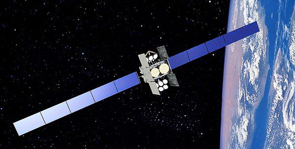
Raytheon is to assist the US Air Force (USAF) in modernising its missile warning architecture, the company announced on 28 January. The resulting system, to be developed under a five-year $197 million (€179 million) contract, will collect and fuse data from an array of sensors, providing a comprehensive picture of launch activity.
Raytheon Intelligence, Information and Services (IIS) has developed a completely open framework to assist in this mission – which the Air Force calls the Future Operationally Resilient Ground Evolution (FORGE) Mission Data Processing Application Framework (MDPAF). It will be capable of processing Overhead Persistent Infrared (OPIR) satellite data from both the USAF’s evolving Space Based Infrared System (SBIRS) constellation and the future next generation OPIR constellation. It will also be capable of processing data from other civil and environmental sensors.
“The .S government’s global satellite network produces a constant flood of data — petabytes and petabytes of it every day,” observed Dave Wajsgras, President of Raytheon IIS. “The Air Force wants to open that network up so they can use as much of that data as possible. That’s a huge transformation, not just for the service, but for the whole government.”
This is a significant departure from previous satellite ground control programmes. Typically, companies would develop a system that collects and exploits data from specific types of satellites or sensors. FORGE changes this model, as it is able to collect data from nearly any type of satellite or sensor, subsequently helping operators make sense of that data quickly.
“Essentially, this is a smartphone model,” explained Wajsgras. “We’ve built an operating system that everyone can build applications for – from Raytheon to the Air Force to universities to small companies. These applications allow the system to process specific types of data.
One of the key benefits of incorporating new applications is that the system can be used beyond its intended mission. For example, an application could be built that would allow civil agencies to use the same satellite data to help detect forest fires, volcanic activity or agricultural changes – even surges in electric power consumption.
Further departing from the traditional ground control development model, Raytheon built the prototype system in less than a year, so that it is capable of processing real data today. The company leveraged development work on several past programmes, especially its Advanced Weather Integrated Processing System, to design the framework. Raytheon also incorporated its deep experience developing applications using DevSecOps and Agile software development processes to dramatically speed development.
Raytheon will work with the Air Force in the coming years to further evolve and prove the framework’s capabilities.